⚠️Not updated in over a year
Description
This extension was created because I had special needs for my territories.
I wished to rotate the maps for better fit in territory-card.
I wanted to change some captions...
Look my new help- and manualpages on https://thelp.mathesoft.eu
-- What does the extension?
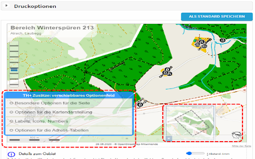
You visit territoryhelper.com and the extension inject a lot of helpful functions and tools.
-- What's new in this version?
v3.10:
- internal bugfixes and updated libraries
- make screenshots from details of the territory card and move them between the address-tables
- export some individual territory from the overview map as GeoJson. So you have a backup, or you may import again for not paint again a complex territory border.
Known problems:
- only supported map system is OpenStreetMap
- export of statistics not possible because changes in layout

Reviews
Loading reviews...
Permissions (1)
Permissions
storageℹ Can store data locally in your browser
Details
| Version | 3.1 |
| Updated | Aug 1, 2024 |
| Size | 1.0MiB |
| First Seen | Mar 31, 2026 |
Popular in workflow

Adobe Acrobat: PDF edit, convert, sign tools
by Adobe Inc.
331M
★ 4.40
workflow
331M
★ 4.40
workflow

AdBlock — block ads across the web
by AdBlock
63M
★ 4.48
workflow
63M
★ 4.48
workflow

迅雷下载支持
by Shenzhen Xunlei Network Technology Co., Ltd.
59M
★ 2.77
workflow
59M
★ 2.77
workflow

Adblock Plus - free ad blocker
by eyeo GmbH
41M
★ 4.39
workflow
41M
★ 4.39
workflow

Chrome Remote Desktop
by Chrome Remote Desktop Release Managers
38M
★ 3.14
workflow
38M
★ 3.14
workflow
Popular Extensions
Adobe Acrobat: PDF edit, convert, sign tools
by Adobe Inc.
331M
★ 4.40
workflow
331M
★ 4.40
workflow
AdBlock — block ads across the web
by AdBlock
63M
★ 4.48
workflow
63M
★ 4.48
workflow
迅雷下载支持
by Shenzhen Xunlei Network Technology Co., Ltd.
59M
★ 2.77
workflow
59M
★ 2.77
workflow

Grammarly: AI Writing Assistant and Grammar Checker App
by Grammarly
42M
★ 4.50
communication
42M
★ 4.50
communication
Adblock Plus - free ad blocker
by eyeo GmbH
41M
★ 4.39
workflow
41M
★ 4.39
workflow